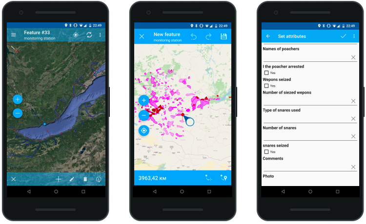
Field data collection with NextGIS Collector

Field data collection technology combining power of Web GIS and a mobile app.

In the modern world fast data collection and transfer gives a company the edge with the competitors.

Since the beginning in 2011 NextGIS is involved with field data collection projects in many different areas, from optic fiber construction monitoring to snow leopard counts in extreme conditions. This diverse experience allowed us to take into account many different nuances to create a powerful yet easy to use technology for field data collection – NextGIS Collector.

Features

  • Quick start for a collector

    Install an app, register and join a project. It’s that simple. No setting up forms and layers, everything is made ready by administrator.

  • Powerful but easy to use configuration for admin

    Set up forms, manage collectors, no programming required.

  • Ready to go

    All components are ready for immediate action once you sign up.

NextGIS Collector includes a set of applications that configure and run the processes.

How does it work

NextGIS Collector makes easier the whole process: from forms to administration and data transfer while you’re in the field to allowing access to these data to other people.

  • Administrator creates a data collection project in Web GIS (NextGIS Web or nextgis.com) and forms a team of users allowed to participate.
  • Form or forms that define what and how is collected are created using NextGIS Formbuilder.
  • Data collectors download NextGIS Collector from Google Play, authorize and immediately see data collection projects available to join.
  • Collected data automatically sync with Web GIS and become available anywhere in the world. Collectors in the field can work offline to sync later when internet connection becomes available.
Simple project can be set in less than 10 minutes. Detailed instructions can be found in the documentation.

Functionality

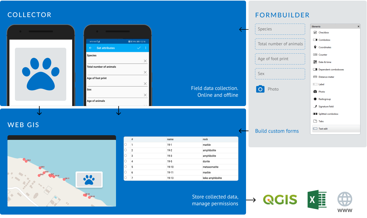
Main purpose of NextGIS Collector is geodata collection. Data might include any number of attributes and attachements like photos and schematics. All collected data will automatically get coordinates.

insert_drive_file Documentation
Preparation and administration
  • visual forms editor, 16 controls (lists, checkboxes, photos etc.)
  • flexible administration system
  • on-premise integration (LDAP)
Data collection
  • geographic data collection through forms and/or maps
  • offline-mode
  • live tracking
Post-processing
  • viewing and editing data via browser (in Web GIS)
  • multi-user access
  • export to desktop GIS (QGIS, ArcGIS, Mapinfo)

Pricing

В облаке

Cloud

Part of  Premium . Includes: 5 accounts (extendable), cloud Web GIS access.
€900/year
€100/month

Sign up

На своем сервере

On-premise

Includes: 50 accounts, NextGIS Web Extended.

€5 000/1st year
€2 500/next year

Contact us

Please contact us if you have questions via chat or info@nextgis.com.

In conclusion

Classic pen and paper data collection are still with us, but life moves and companies more and more often require operational, structured and ready-to-use geodata.

NextGIS Collector is an optimal choice configurable for just about any project.

Let us know if you’re interested in using NextGIS Collector or sign up to Premium and start using this technology right now, support included!

Links

NextGIS Collector documentation

Comments are closed.