Sustainable use of fish resources is impossible without monitoring and studying the dynamics of fish populations, and GIS is one of the best tools available for this research. In 2020-2021, a team of scientists from the Khabarovsk branch of the All-Russian Research Institute of Fisheries and Oceanography (VNIRO) evaluated fish resources in Russia’s Far East. To collect data, scientists used remote-controlled autonomous underwater vehicles (AUVs) and unmanned aerial vehicles (UAVs) or drones.
Let’s explore how VNIRO’s scientists used NextGIS tools for two of their studies: measuring the herring spawning grounds in the Sea of Okhotsk and accounting of the Pacific salmon. Research papers published based on these studies are included at the bottom.
NextGIS technology helped researchers collect geoinformation, navigate the research vehicles, and analyze the data. This project is an example of effective interaction of our platform’s three main components – NextGIS Mobile, NextGIS QGIS and NextGIS Web.
To measure the herring spawning grounds in the Sea of Okhotsk, VNIRO’s team used AUV’s, little remote-controlled submarines equipped with cameras. The AUVs traveled to the underwater “roe survey stations” set out by researchers, took pictures and transmitted them to the above-water team of scientists.
The research team used two smartphones to record data: One phone was using the Chasing GO1 app to receive underwater images from AUVs over WiFi and to take screenshots with images of row survey stations. The second smartphone had the NextGIS Mobile application installed. It was used for orienteering and track recording.
Before starting work, satellite images, topographic maps, caviar survey stations and sections were uploaded into the NextGIS mobile application. As the boat moved from survey station to survey station, the NextGIS Mobile application recorded the track in the background. The attributive data of the stations (coordinates, date and time) were recorded automatically and the station numeration was submitted by specialists into pre-prepared forms.
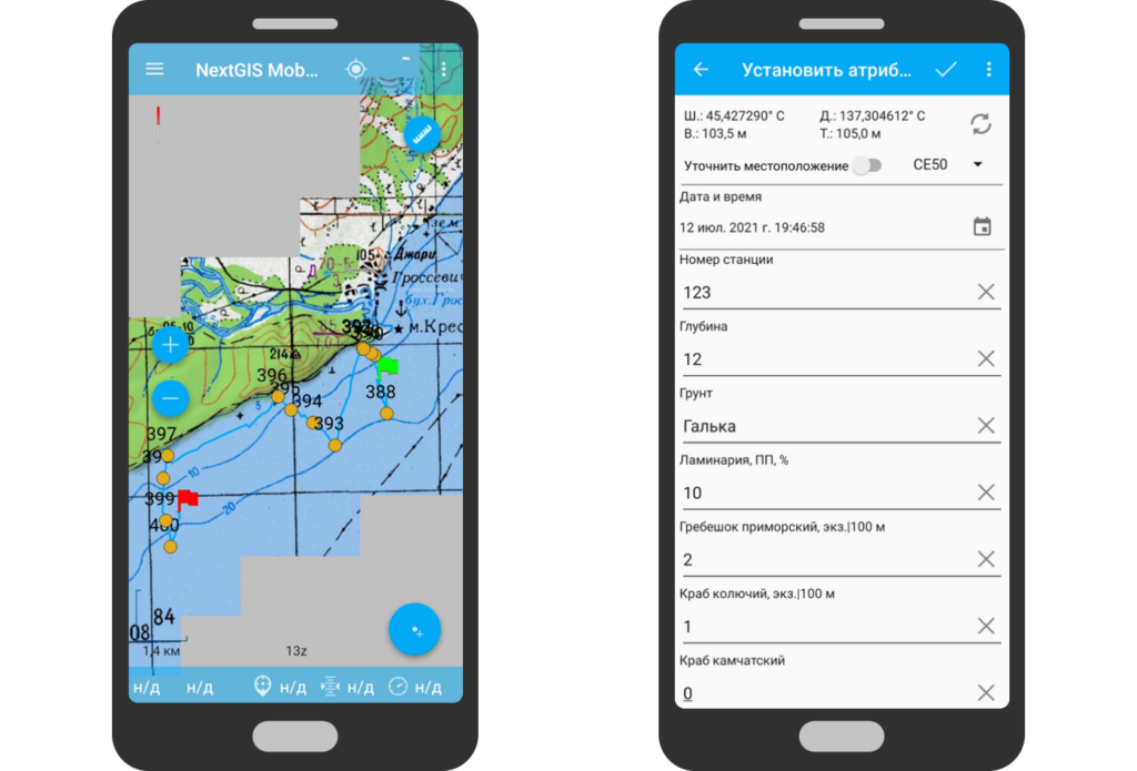
The study used consumer-grade ROVs that are not equipped with underwater positioning of echolocation systems. Also, GPS and GLONASS (Russia’s national geopositioning system) were not available underwater. That meant that the screenshots taken by the research team did not contain information about the location – only the timestamp when they were taken. The time data recorded in the NextGIS Mobile GPX track made it possible to attach screenshots to the corresponding track points.
Snapshots were spatially referenced using GPX tracks recorded in NextGIS Mobile. To do this, using the free GeoSetter application, time metadata from the screenshots was synchronized with coordinate track data. These coordinates were then automatically recorded in the metadata of the images.
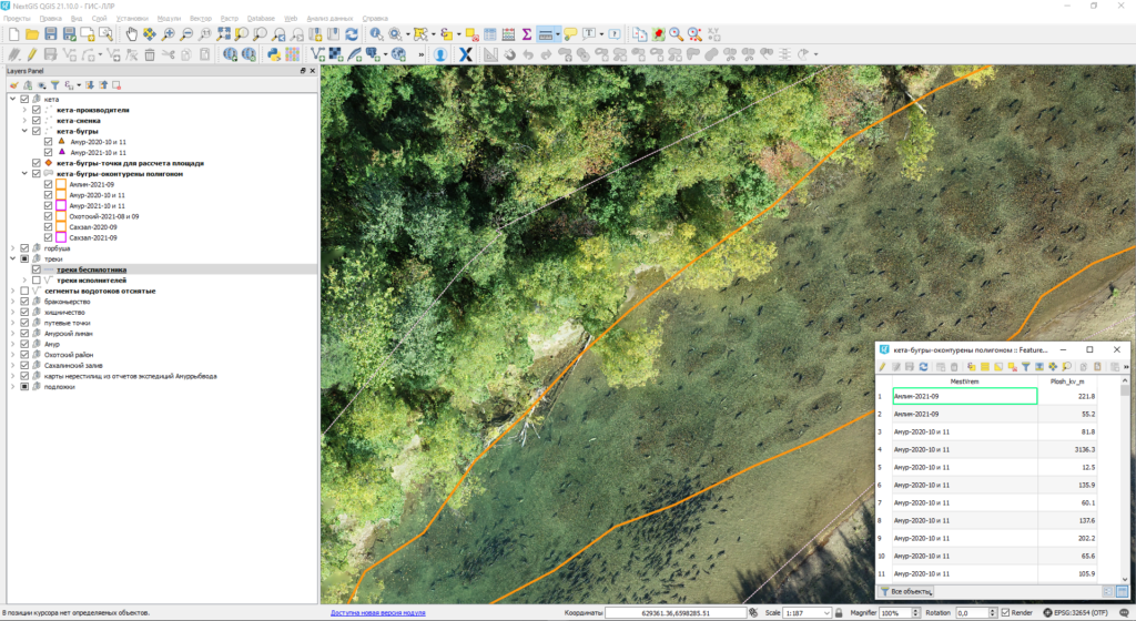
The team used the desktop NextGIS QGIS application to process the data on UAV tracks with the associated screenshots. Based on the images and their attributes, the specialists created datasets containing data from roe surveys as well as information about the dates/times, coordinates, depths, water temperatures, soils, and the composition of the algae belt. In the end, with the help of NextGIS QGIS digitizing tools, the team estimated the area of the algae belt and the herring spawning grounds.
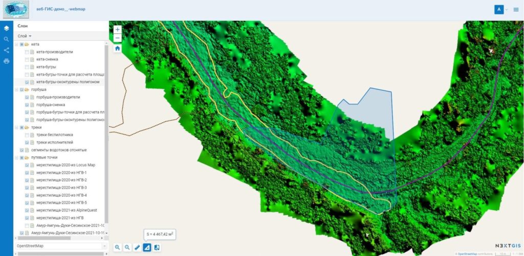
The server-based NextGIS Web was used in VNIRO’s second study aimed at counting Pacific salmon.
Scientists obtained primary data using drone footage. Special photogrammetric software was used to convert survey materials into orthomosaics and DTMs. The processed data was organized using the NextGIS QGIS application. Whenever the field team could access the internet, the findings were immediately published using NextGIS Web right in the field.
Thanks to the fact that NextGIS web provides multi-user access to online maps, additional project stakeholders, including fisheries regulators, had ongoing access to data being collected in the field.
The field researchers note that the intuitive interface of NextGIS Web allows people without special technical skills to participate in analyzing the information collected. According to the study authors, web GIS technology can provide a model for monitoring and regulating salmon fishing.
The server-based NextGIS Web was used in creating an online map. This solution was chosen because of VNIRO’s prior effective use of desktop, server and mobile geoinformation software from NextGIS.
The VNIRO studies show that whenever field data are involved, it is especially useful to have access to a set of mobile, desktop and online tools that work in concert. The goal of the study of the herring spawning grounds was in fact to develop a new approach to collecting and processing underwater geodata using modern technology. The study of the Pacific salmon population shows how geodata can be seamlessly shared with a large team of participants.
You can create your own Web GIS and get full access to NextGIS mobile, desktop and web software by registering for Premium on our website. You do not need specially trained personnel or programming skills to work with the platform. Web GIS can function both in the cloud and on your own servers.
Purchase Premium


