New version of NextGIS Connect 0.8 is out. NextGIS Connect helps you link your desktop and your Web GIS if you created one at nextgis.com.
Here is what’s new:
New Web GIS vector layers icons
Vector layers in the resources tree will show the type of geometries they contain:
New posibilities for data upload
Now you can import more types of layers to your Web GIS:
Validation and conversion imported layers
If layer has no geometries (CSV table for example), it will not be imported. If such layer is part of a project it will be skipped. Same goes to layers which geometries QGIS defines as invalid.
If layer contains features of both single- and multi-part geometries (the problem ESRI Shapefile format), all features will be converted to multi-part on upload:
If the checkbox not set, module will try to load layer without conversion.
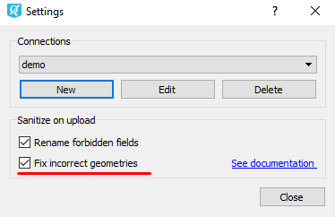
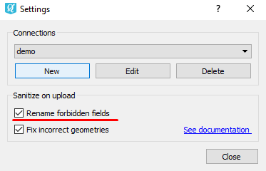
If layer has fields named ‘id’, ‘type’, ‘source’ (currently prohibited in nextgis.com), these names will be transformed to the form ‘idN’, ‘typeN’, ‘sourceN’, where N is the number that is selected so that the field name does not match with the names of existing fields. Name transformation will be performed if the corresponding checkbox is in the module settings:
If the checkbox not set, Connect will try to upload layer without conversion.
Important note. If field names are changed, then the style is applied to this layer may become invalid, if it uses fields with the original names.
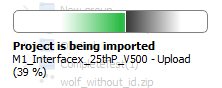
Upload progress
We’ve also added a progress bar to show the progress of the preparation and loading of layers and projects in Web GIS.
You can find more information on NextGIS Connect in a special section of Get Started with your Web GIS manual.


