After 10 years of developing the NextGIS Connect plugin for QGIS, we are proud to introduce the latest update. We have radically transformed the plugin, enabling users to manage online geodata in Web GIS from their desktop GIS with unparalleled ease, speed, and efficiency.
In this post, we will review each feature, accompanied by video tutorials. At the end of the article, you will find information about an upcoming live demo webinar, where we will demo the new version of the plugin.
Geographic Information Systems deployed in the cloud or on a server often rely on desktop tools for advanced data management. NextGIS Connect is a plugin designed to use QGIS for managing spatial data stored in NextGIS Web. With Connect you can:
You can now edit vector layers from your Web GIS immediately after adding them to QGIS. Changes made in QGIS are instantly reflected on the web.
Editing is possible in offline mode, without an internet connection.
When you start editing a NextGIS Web layer in QGIS, a sync icon will appear next to it. Click on that link to check the update status of the layer.
As a result, now you can perform direct editing of your Web GIS data both through the WFS service (online) and also through the new NextGIS Connect functionality (online and offline).
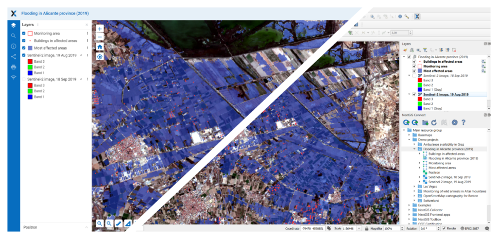
Do any of your Web GIS maps need an update? Do you need to distribute a Web Map to colleagues for editing or offline browsing in QGIS? Now this is possible! You and your team can add an entire Web Map to QGIS! It will be presented as a project with layers, styles, and basemaps. Your colleagues can then save the map locally and edit it independently offline or edit the Web Map in real-time.
A Web Map in NextGIS Web is the equivalent of a QGIS project. It similarly contains layers, styles, and other settings.
When working with a layer in QGIS, you can use other layers and tables as connected dictionaries. Similarly, in NextGIS Web, you can create a Lookup Table and connect it to a layer field. Now, when you send such a layer to NextGIS Web or retrieve it in QGIS, the connection will remain intact.
In QGIS, you have a layer with geometries and a layer without geometries (a table), which you use as a Lookup Table. When you send the layer with geometries to your Web GIS, a Lookup Table will also be created based on the table values from QGIS. Thanks to this, you will be able to continue editing the layer in Web GIS just as you did in QGIS.
In your Web GIS, there is a vector layer with a connected Lookup Table. When you add this layer to QGIS, you will continue using the Lookup Table just as in Web GIS.
You can now add your Web GIS basemaps to your QGIS. The same applies to TMS and PostGIS layers.
You can now create a style for a PostGIS layer in QGIS and send it to your Web GIS.
Demos are NextGIS Web projects that users can add to their own Web GIS to test platform functionality or explore industry applications. Now, you can also add them to QGIS with Connect.
Use this opportunity to gain new skills and learn how to work with spatial data and Web GIS.
Our corporate GIS solutions — the desktop NextGIS QGIS and the cloud-based NextGIS Web — support third-party authentication systems Keycloak. Keycloak is an identity management product stewarded by Red Hat.
NextGIS Connect, which links the desktop and Web GIS, is now compatible with geographic information systems where authorization is conducted through Keycloak.
This enhancement is relevant for corporate users who have Web GIS deployed on their own servers.
To initiate NextGIS Connect from QGIS, you need to authenticate in your Web GIS. Now, authentication is conducted through the QGIS Authentication Manager, a QGIS tool that stores all your authentication credentials for linked services.
This update makes your credentials more secure.
The presentation took place on Wednesday, July 3, 2024.
Create a Web GIS in the cloud by signing up for Premium. Contact us if you would like to deploy Web GIS on your own server.
Install QGIS with the NextGIS Connect plugin, and start managing your cloud geodata from your desktop!
Hundreds of our clients use the NextGIS Connect module in QGIS to manage their Web GIS data. Your suggestions and comments help us improve this tool, so any and all feedback is valuable. Please report any errors you encounter to info@nextgis.com or write to us in our Telegram chat.