In 2024-2026, NextGIS participated in the large-scale project Ecosystem Accounting in Armenia: Setting the Scene. The project was initiated by the Leibniz Institute of Ecological Urban and Regional Development (Germany) and the Biodiversity Conservation Center of Armenia (BCC). The goal of the project was to prepare Armenia for the implementation of a national ecosystem accounting system using modern geospatial technologies.
Ecosystem accounting is based on the analysis of ecosystem services, the processes and functions of nature that support human well-being and sustainable territorial development. These services are measurable processes such as water filtration, soil erosion control, pollination, carbon sequestration, and flood protection. Ecosystem accounting makes it possible to assess and forecast the dynamics of these services over time.
The project focused on regulating services, those that sustain critical natural processes. A functioning ecosystem accounting system must continuously evaluate these services and the factors influencing them. NextGIS was responsible for the full workflow: data preparation, ecosystem service modeling, and public communication of results via web maps.
One of the key principles of the project was the use of open global datasets. This ensures transparency and allows the methodology to be replicated for any other region.
We reviewed dozens of datasets covering land cover, terrain, soils, and vegetation. After careful comparison and validation, a working dataset was assembled.
| Landcover | ESRI Land Cover |
| Soil | Interactive Forest Atlas of Armenia FAO ESDAC |
| Elevation | Copernicus DEM |
| Hydrology | HydroSHEDS |
| Climate | WorldClim Interactive Forest Atlas of Armenia Global Aridity and PET Database |
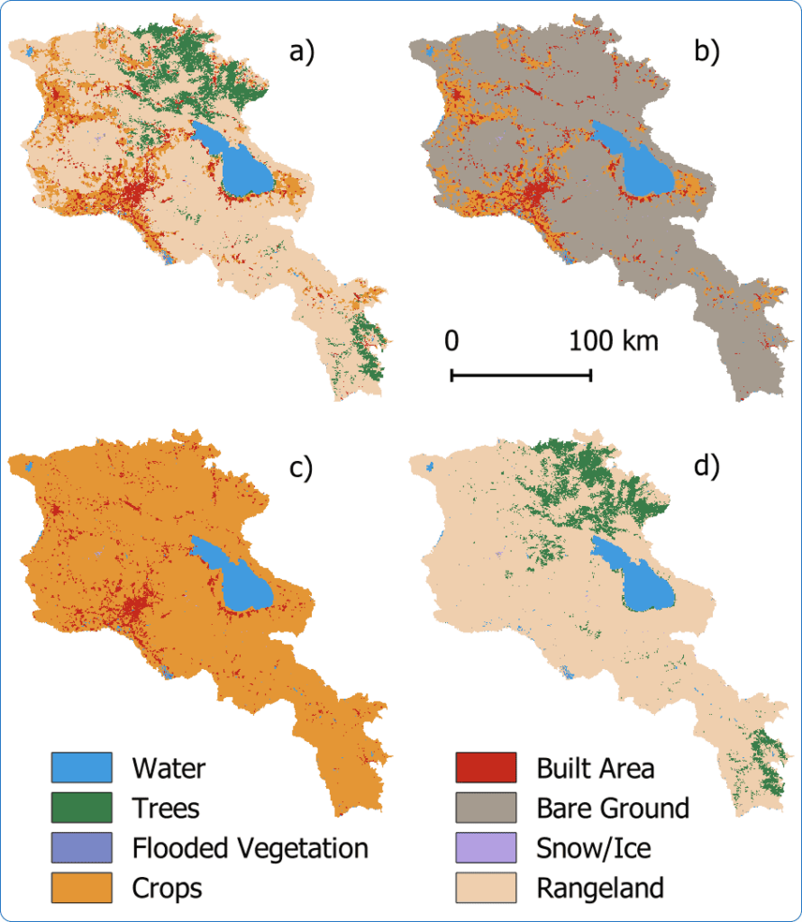
Land cover became the foundation for all modeling workflows. ESRI Land Cover data was selected due to its availability of historical records and a clear update policy, both essential for annual monitoring.
For the analysis, we used InVEST (Integrated Valuation of Ecosystem Services and Tradeoffs), a suite of open spatial models designed to assess ecosystem services and natural capital.
These models enable quantitative analysis of how land use and management changes affect services such as water availability, runoff regulation, flood protection, carbon storage, urban cooling, and more.
We applied four key models:
To assess the real contribution of ecosystems, each model was applied across four scenarios. A scenario-based approach allows us to simulate the consequences of removing specific land cover types:
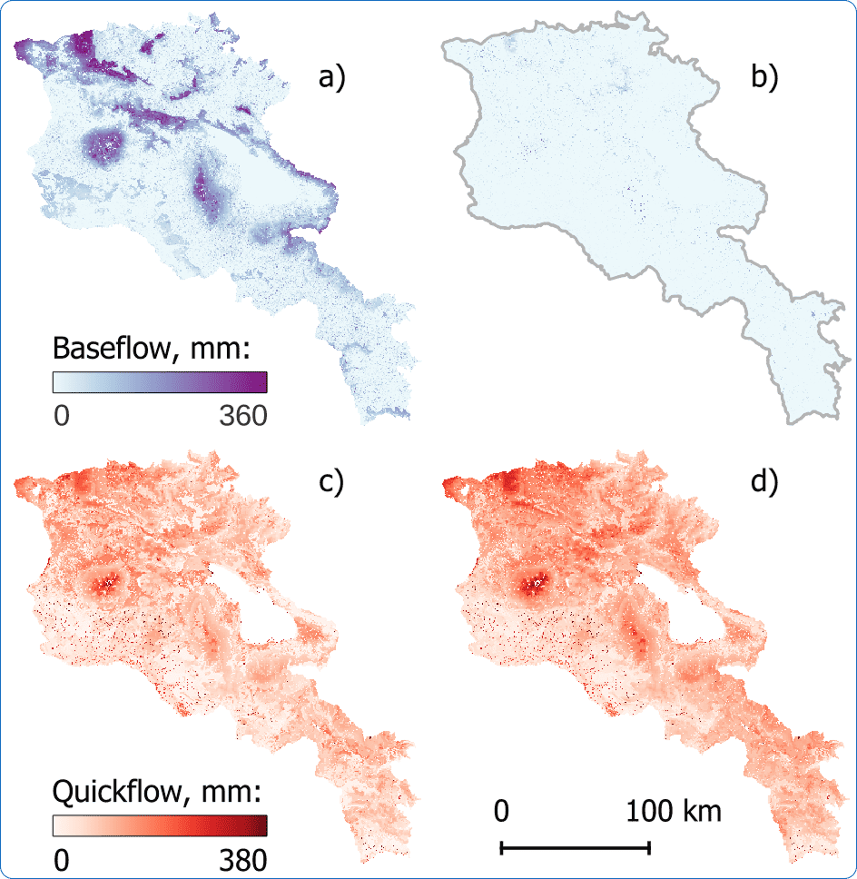
All models confirmed the critical regulating role of natural ecosystems. For example, natural ecosystems provide up to 90% of baseflow, the water that sustains territories during dry periods. When vegetation is removed, baseflow drops dramatically, while rapid runoff during rainfall events increases sharply.
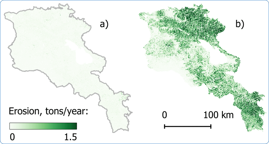
Soil erosion under the “bare ground” scenario clearly demonstrates that natural ecosystems almost entirely prevent soil degradation.
A key advantage of the applied models is that they produce quantitative outputs, enabling direct comparison between territories.
Model outputs were aggregated at the level of river basins and marzes (administrative regions of Armenia), allowing alignment with official statistics.
A representative example is the comparison between Sediment Delivery Ratio results and regional water consumption data. In Lori Province, natural ecosystems prevent the loss of approximately 119 kg of sediment per cubic meter of water used annually. In contrast, in Armavir and Ararat provinces, this показатель is less than 1 kg/m³. The difference is explained by ecosystem condition and terrain characteristics.
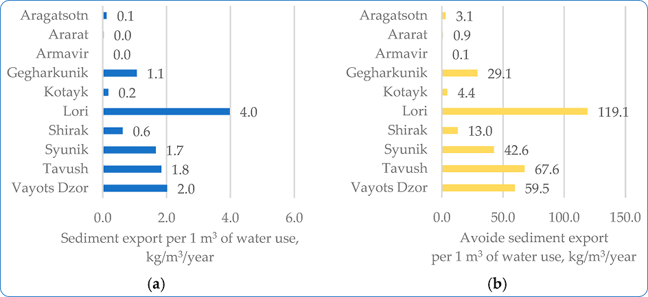
Such calculations make it possible to assess the importance of a specific ecosystem service. In the example above, erosion prevention.
All project materials were published from the outset in an open Web GIS based on NextGIS Web. This addressed several key challenges:
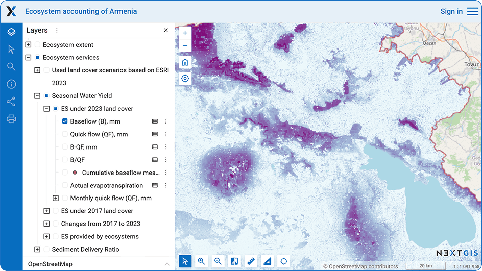
Local experts were able to flag questionable results at early stages, triggering discussions that improved the methodology during the project.
The project established a comprehensive foundation for a national ecosystem accounting system in Armenia using only open data and reproducible methods. All datasets and maps are available through the public Web GIS.
Elena Bukvareva, Scientific Supervisor of the project (BCC Armenia), noted:
NextGIS specialists provided comprehensive and highly professional support in GIS methods and mapping. Based on available open data, digital maps of natural landscapes and terrestrial ecosystems were created, a fundamental requirement for ecosystem accounting. For modeling and mapping key water regulation and soil protection ecosystem services in Armenia, NextGIS experts rapidly processed the required data in InVEST models and produced a complete set of ecosystem service maps and supporting statistics. The methods and results achieved by NextGIS are at a high international level, not previously reached in Armenia. The project Web GIS also proved extremely valuable for presenting results to government agencies, the scientific community, and environmental NGOs.
Elena Bukvareva, Scientific Supervisor of the project (BCC Armenia)
As part of the project, three scientific papers were published in international journals, including Sustainability and International Archives of the Photogrammetry, Remote Sensing and Spatial Information Sciences.
A detailed description of the results is available on the project website.


