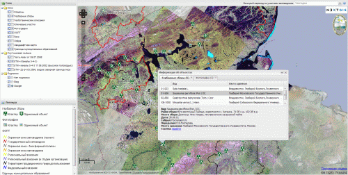
NextGIS has completed the development of Web-GIS for the State Natural Biosphere Reserve “Taimyrskiy.”The system is designed to display information about the reserve and surrounding areas.
Currently, the list of layers includes: inspector huts, herbarium collections, geobotanical descriptions, key areas, protected areas, rivers, lakes, a landscape map, boundaries of municipalities, and photos. Layers are based on vector data and published via WMS, which allows them to be used not only in this Web-GIS, but in various other GIS applications. Another group of layers is based on raster data—satellite images for the area.
Some of the layers (“Herbarium Collections,” “Geobotanical Descriptions,” and “Photos”) allow interaction; the user can click on displayed objects to fetch detailed information.
It should be noted that this project used the possibility of server side points clustering, which first appeared in MapSever 6.0.Project’s website: http://taimyr.info
The system is built completely on opensource software: GDAL, MapServer, TileCache, OpenLayers, GeoExt.

