


NextGIS Toolbox:
A Powerful Toolkit for Geoprocessing
Automate and Streamline Your Workflows: process raster and vector data, Convert tables to spatial data, Integrate with cloud or server-based GIS, Prepare satellite imagery.
100+ tools
Fully automated workflows
Cloud and on-premise
Choose a tool and simply fill out the form
Most tools take from a few seconds to under a minute to run.
Possible inputs:
Data layers in different formats
Resources from your Web GIS
CSV, XLSX tables
Possible outputs:
Spreadsheet reports
Processed data layers
Modified data
in your Web GIS
Integration into Your Workflows via API
NextGIS Toolbox can be used not only through the web interface – every tool is available for remote execution via API. This allows you to embed geoprocessing into your own scripts, services, and automated pipelines.
What the API Enables
- Automation of routine operations – run tools on a schedule or in response to events.
- Integration with your systems – connect Toolbox to corporate services, ETL processes, and CI/CD pipelines.
- Scalability – process data in batches without user interaction.
- Repeatability – the same parameters produce the same result, which is ideal for reporting and regulated tasks.
Ways to Work with the API
You have two options:
1. Direct HTTP Requests
Each tool provides:
- an API endpoint;
- parameter descriptions;
- a Python request example;
- a personal authorization token.
This makes it easy to integrate any tool into your existing codebase.
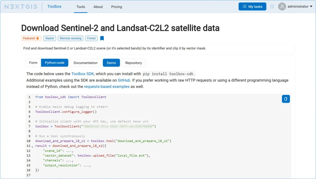
2. Toolbox SDK – the Official Python Client
If you prefer to write less code and work more conveniently, use the official SDK.
The SDK provides:
- logging and error handling;
- a convenient Python client for Toolbox tools;
- synchronous and asynchronous calls;
- automatic file upload and download;
- progress tracking;
- tool chaining.
Pricing and Support
First year: from €3,500/year
Includes setup assistance and support
Subsequent years: from €1,750/year
Ongoing support and updates
What’s Included:
- Integration assistance
- Professional deployment and configuration
- Priority support channel
- Software updates and security patches
Need a new tool to automate your geoprocessing tasks? Fill out the form.
Deployment and OS
- Deployed with Docker
- Linux-based OS:
- Ubuntu
- Debian
- CentOS Stream