Organizations across telecommunications, utilities, logistics, and infrastructure sectors collect massive volumes of operational data – but transforming that raw data into actionable business intelligence remains a challenge. When a global telecom‑equipment vendor needed to make their network performance data accessible to business analysts, sales teams, and executives – not just engineers – they partnered with NextGIS to develop Connect Force: a web-based geospatial business analytics application.
The result: A comprehensive platform that transforms complex infrastructure metrics into visual, map-based insights to drive strategic planning, competitive analysis, and customer acquisition decisions.
Key capabilities delivered:
This case study is an example of NextGIS’s capacity to develop custom geospatial applications that bridge the gap between technical data and business decision-making – with applications beyond telecommunications.
The Customer of this project is a leading provider of network testing, monitoring, and assurance solutions worldwide. Through instruments, systems and technologies offered by the Customer, telecom service providers, network equipment manufacturers, and IT organizations can test, monitor and optimize the performance of complex 5G and fiber optic networks throughout their lifecycle.
One of the solutions offered by the customer was a special intelligence platform for network integrated tests, real-time analytics and optimization. It is a powerful instrument to accomplish various engineering tasks and help enterprise customers reduce expenses, find new income streams, and improve performance.
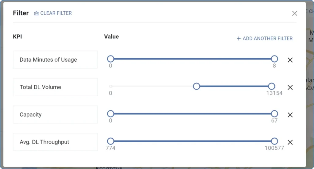
The opportunity: An important benefit of the intelligence platform is the availability of a raw data feed, allowing to assess network performance for specific timestamps and analyze it from both engineering and business development perspective.
The gap: Present data in ways that would allow diverse engineers, business analytics, sales and financial specialists, and executives to gather actionable insights that meet their diverse individual needs.
This challenge reflects a common problem across industries:
In each case, the technical data exists, but making it accessible and actionable for business decisionmakers requires translating complex metrics into geographic, visual, and comparative formats that reveal opportunities and priorities.
To address the challenge, NextGIS developed a web-based, map-integrated component for the intelligence platform, enabling clients of the Customer to use the available data stream for business analysis and reporting.
The main goal of the project was to use network metrics for business development research, performance analysis, and strategic planning for future networks. More broadly, NextGIS aimed to enable any team member – regardless of technical expertise – to:
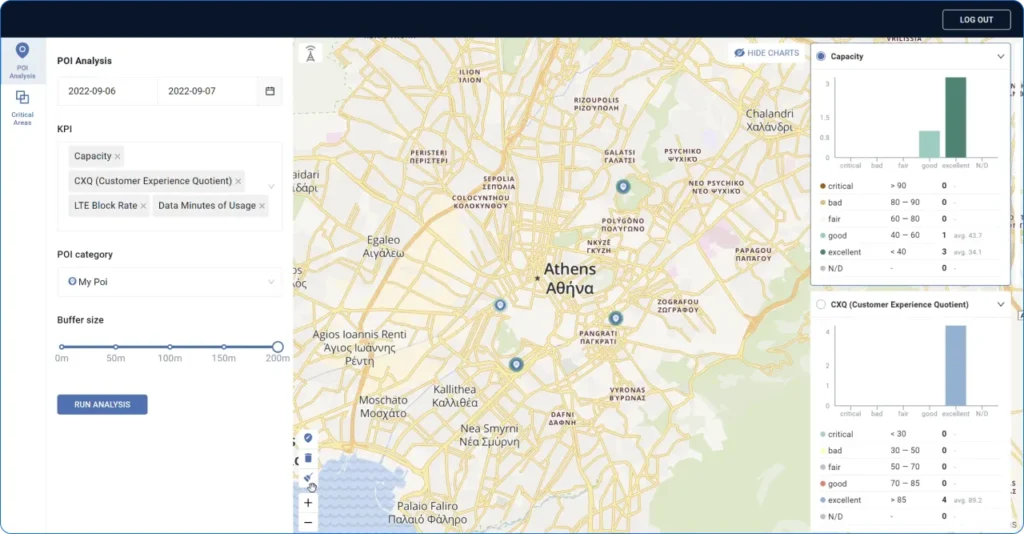
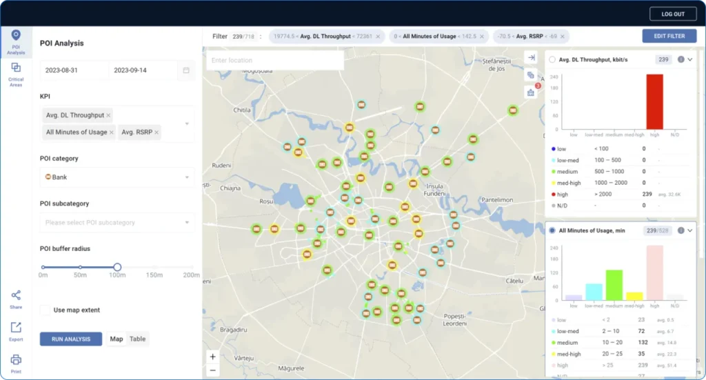
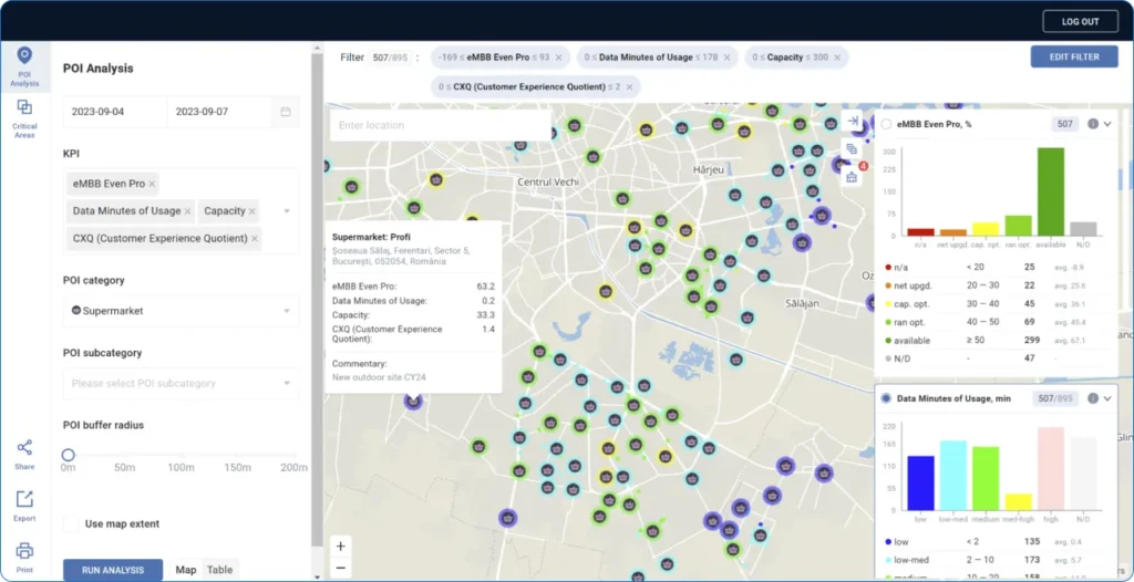
The Geographic Analysis Engine accesses the raw data feed from the intelligence platform, processes it, and presents it in an easy-to-read and understand format for a wide range of stakeholders. A key element of the engine is the Point of Interest (POI) approach to analyze network performance at business-relevant locations such as transportation clusters, competitor sites, or custom locations rather than sifting through thousands of technical measurement points.
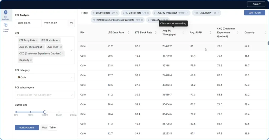
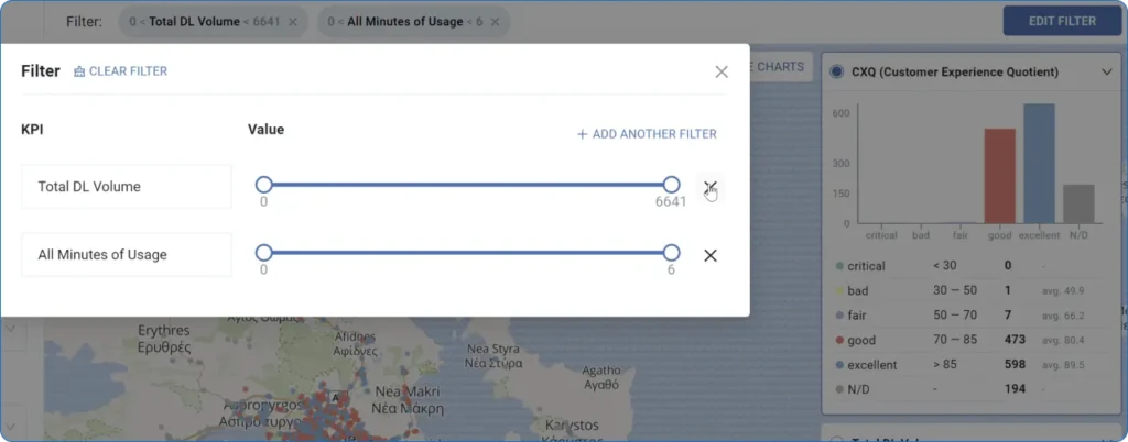
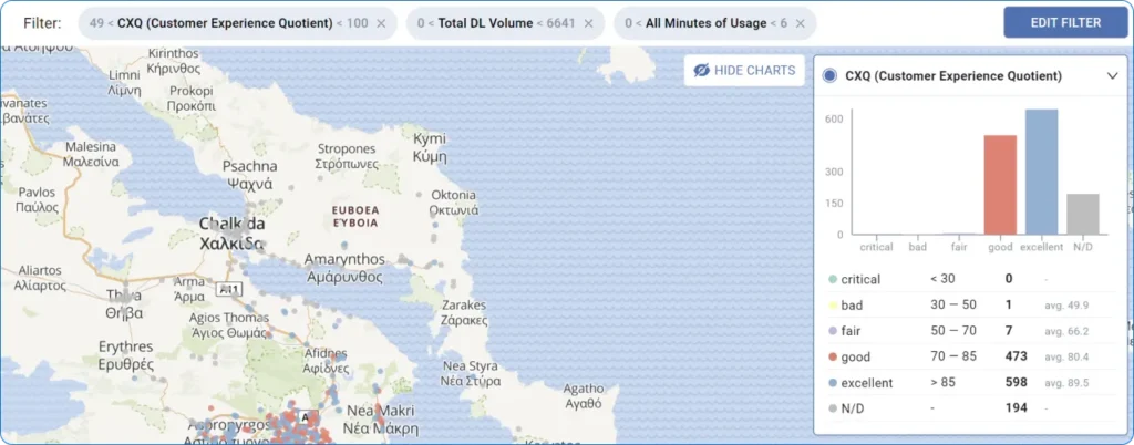
Decision Support Tools provide multi criteria decision analysis (MCDA) instruments to define the areas of potential interest based on location and network KPIs. Another set of tools compares client vs. competitor network performance.
Reporting and Collaboration allow clients to download, share, and print analysis results in a variety of formats.
Rapid prototyping: An alpha version of the application was up and running in three months from the start of the project. After successful tests, the Customer decided to build additional functionality into the application.
Iterative development: Development continued over the following year based on feedback from the Customer team.
NextGIS’s own open-source tools were used as the foundation of Connect Force:
In addition, NextGIS used an OpenStreetMap Nominatim instance as a search engine and a Vertica Analytics Database to import, process and store the raw data feed.
Business value: Instead of forcing business users to interpret data in tables, the POI analysis tool lets them define locations that matter to their business – transportation clusters, retail stores, competitor sites, high-traffic areas, underserved markets – and analyze infrastructure performance at those specific points.
Features and Insights:
Business value: These tools make competitive intelligence visual and location-specific. Infrastructure and sales teams can identify exactly where they’re outperforming or underperforming competitors – and prioritize both defensive and offensive strategies geographically.
Features and Insights:
Business value: Analysis insights can be immediately shared with decisionmakers in their preferred format, accelerating the path from data to action.
Capabilities:
Business value: The client maintains full control over their mapping infrastructure, ensuring security, customization, and performance without dependence on third-party services.
To facilitate this level of control and security, Connect Force incorporated NextGIS Geoservices, a powerful web-based application providing users access to base map services from multiple providers with on-premise management, authorization and logging.
During the iterative development phase of the project, NextGIS developed a wide range of additional enhancements to Connect Force, including:
Several differentiating factors made NextGIS the right partner for this complex application:
Open-Source Foundation: Our open-source technology stack provides transparency, flexibility, and freedom from vendor lock-in.
Proven Platform Foundation: Cohesive suite of GIS products, services, and tools (NextGIS Web, Geoservices, Frontend) provides core functionality out-of-the-box, accelerating development timelines and delivering more integrated solutions than building from scratch or assembling disparate third-party components.
Rapid Development-to-Deployment Model: Deep geospatial expertise combined with our efficient development approach enables rapid delivery of functionality.
Advanced Customization Expertise: Demonstrated ability to extend the NextGIS Web framework with sophisticated business intelligence capabilities including custom calculation engines, multi-criteria decision analysis (MCDA) tools, POI-based analytics, comparison algorithms, and reporting systems tailored to specific business needs.
Integration-Ready Architecture: Built-in capability to connect with external systems through standardized APIs and database connectors.
While Connect Force was developed for network performance analysis, the underlying capability – transforming infrastructure or operational data into location-based business intelligence – applies across industries:

Utilities & Energy

Logistics & Transportation

Retail & Real Estate

Smart Cities & Public Infrastructure
In each case, the pattern is the same: operational or infrastructure data exists, but business value requires geographic context, comparative analysis, and accessible visualization.
Connect Force was built on and extended the NextGIS platform – a comprehensive suite of open-source geospatial tools designed for enterprise use:
Organizations can leverage these tools for their own custom geospatial applications, benefiting from:
Learn more about the NextGIS platform at www.nextgis.com
Geospatial analysis adds significant value to business intelligence. NextGIS enables our clients to realize this value by using our open-source platform independently or engaging us for custom development projects.
What this case study demonstrates:
If your organization requires a similar GIS solution – whether in telecommunications, utilities, logistics, real estate, or any industry w


